
An Interest In:
Web News this Week
- March 30, 2024
- March 29, 2024
- March 28, 2024
- March 27, 2024
- March 26, 2024
- March 25, 2024
- March 24, 2024
Some of Our Sources
- Slashdot
- Technology Review
- Pearsonified
- Six Revisions
- Fuel Your Creativity
- Inspiredology
- Naldz Graphics
- Noupe
- 24 Ways
- Design Modo
Help Webnuz
Referal links:
December 8, 2016 11:37 pm GMT
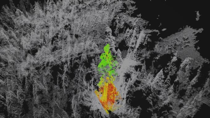 Droughts, climate change, and deforestation are putting forests at risk worldwide, so studying these ecosystems closely is more important than ever — but it’s a hell of a lot of work to climb every tree in the Sierra Nevada. Drones and advanced imaging, however, present an increasingly practical alternative to that, as a UC Berkeley project shows. Read More


Original Link: http://feedproxy.google.com/~r/Techcrunch/~3/vbckAn_Y_Xg/
Berkeley project tests tracking imperiled forests with 3D multispectral drone imaging
Droughts, climate change, and deforestation are putting forests at risk worldwide, so studying these ecosystems closely is more important than ever — but it’s a hell of a lot of work to climb every tree in the Sierra Nevada. Drones and advanced imaging, however, present an increasingly practical alternative to that, as a UC Berkeley project shows. Read MoreOriginal Link: http://feedproxy.google.com/~r/Techcrunch/~3/vbckAn_Y_Xg/
Share this article:
Tweet

View Full Article
Techcrunch
 TechCrunch is a leading technology blog, dedicated to obsessively profiling startups, reviewing new Internet products, and breaking tech news.
More About this Source Visit Techcrunch