Some of Our Sources
- Team Treehouse
- Just Creative
- The Logo Smith
- Smashing Magazine
- CSS Globe
- Web Resource Source
- Codrops
- Willems Lab
- Daily Now
- Hashedout
Help Webnuz
Referal links:
The Mercator Puzzle reminds you how deceptive maps can be
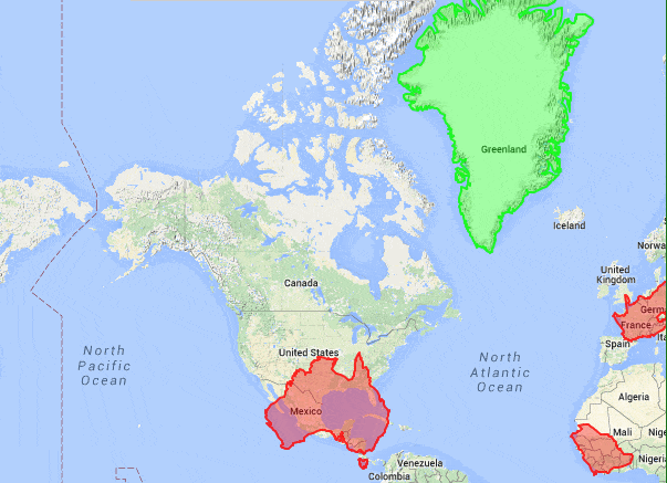
The Earth is round, and maps are flat. While we have may mapped nearly every inch of our world, figuring out how to translate that information from three dimensions to two remains a problem.
Most maps use the Mercator projection, which distorts the size of countries closer to the poles. An online puzzle reveals just how deceptive—or at least confusing—these maps can be about the actual size of different countries on Earth, by asking you to match the outlines of 15 landmasses to the appropriate country. The trick is that as you move these outlines north and south, they grow dramatically larger and smaller.
If you've never realized that seemingly massive Greenland is actually smaller than Australia, go ahead—blow your mind. The Mercator Puzzle is free to play in browsers.
Original Link: http://feeds.boingboing.net/~r/boingboing/iBag/~3/Ah943N6ny4Q/mercator-puzzle.html